Skip to main content
Log in
Toggle navigation
Menu
About Us
Browse
Communities
Collections
Digital Heritage
Anishinaabemowin
Home
Browse Digital Heritage
Map
Browse
Browse Digital Heritage
Map
Browse
Browse
Search
Search
Reset
Sort
Search Relevance
Date Changed
Date Added
Alphabetical
Content Type
Digital Heritage (15)
Apply Digital Heritage filter
Category
Connections to the Land (15)
Apply Connections to the Land filter
Keywords
(-)
Remove Map filter
Map
Media Type
Image (12)
Apply Image filter
File (3)
Apply File filter
Community
Library Of Congress (LOC) (15)
Apply Library Of Congress (LOC) filter
Collection
Maps (14)
Apply Maps filter
1700s (10)
Apply 1700s filter
1800s (3)
Apply 1800s filter
1600s (2)
Apply 1600s filter
Library Of Congress (LOC) Collection (1)
Apply Library Of Congress (LOC) Collection filter
List
Grid
Map of Northern America and Part of Southern America from the Mouth of the Saint Lawrence River to Cayenne Island with the New Discoveries of the Mississippi River or Colbert River
Digital Heritage
Community
Library Of Congress (LOC)
Category
Connections to the Land
Geographical Map of New France Made by Mr. de Champlain of Saintonge, Ordinary Captain for the King's Navy
Digital Heritage
Community
Library Of Congress (LOC)
Category
Connections to the Land
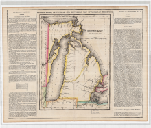
Geographical, Statistical, and Historical Map of Michigan Territory
Digital Heritage
Community
Library Of Congress (LOC)
Category
Connections to the Land
« first
‹ previous
1
2